The next morning our upward climb truly began! We left the flat glacial valleys of the Rhone river and continued up the narrow uphill gorges into the Alps. That first uphill day reminded me of hiking in the Pacific Northwest with pine trees and mountains surrounding us.
 |
| Good morning Martigny! |
 |
| We begin the climb |
 |
| Trails |
In the morning we hiked up onto the slope of the mountain ridge and followed that line until we descended into the basin and crossed over to the other side. There was a lot of ups and downs, and it was such a practice in mental fortitude because every time we would climb up a hill and gain some altitude we would proceed to go downhill and lose most of that altitude! Every time we started walking downhill we were all upset!
 |
| Beautiful scenery |
 |
| and foliage! |
The views continued to be spectacular, and I always had my camera out taking pictures. There were tiny Swiss villages up on the mountainsides and cows all around. Living up to cultural expectations all the cows wore bells on their collars; each a different size so that when all combined their ringing was a musical cacophony of notes.
 |
| It's a long way down |
 |
| Rest time! |
 |
| We started seeing signs for Jerusalem! |
 |
| My trusty toilet paper roll at the ready! |


When we stopped down in the valley town for a break and some coffee-- which we promptly poured over ice– the woman was so excited that we were pilgrims walking the Via Francigena that she gave us croissants free of charge and wouldn't take money for our drinks! We've found that the people in Switzerland are much easier to talk to in French as they seem to have more patience and don't immediately correct or switch to English. This was super helpful for my mom who is learning French as she was able to practice each time we talked with the locals! The Swiss have all been very friendly and helpful so far.
One thing we noticed right off the bat was how neat and tidy the Swiss were. There was rarely any trash or litter along the sides of the road-- NOT the case in France and Italy!! Also, most of their towns and homes were clean and organized. All hedges trimmed and flowers blooming. All lawns freshly mowed and gardens colorful! We saw tons of these "Rombo"-like lawn mowers! My dad loved them, and you could often see lawns that clearly used them by the little lines made from the robot!
 |
| Rombo lawnmower |
 |
| Rombo lawnmower tracks |
From the town, we continued up the slope on the other side of the gorge. This section was awesome! There were so many fallen rocks from the mountains above, and the trail twisted and wound around the debris. Several false trails led off into the hinterlands, so we had to be assiduous in following the yellow diamonds. Mom was in the lead and fiercelessly led us to safety!
 |
| Following the yellow diamonds |
 |
| So excited about this big rock! |
 |
| Mom was our intrepid leader! |
 |
| Waiting for the slowpokes... |
Early afternoon we made it to the quaint little town of Sembrancher. Walking into the town, we noticed many tall, square wooden buildings that looked very old. These are raccards which were used as storage barns for corn and cereals. Several of them had the coolest steps up to their doors! Pieces of slate had been placed in the side of the walls to form a low profile stairway!
 |
| A raccard stairway |
 |
| Water time! |
Sembrancher was a typical gorgeous Swiss village with clean and colorful little Swiss chalets and copious amounts of red flowers decking the window sills. Everything neat and organized! A veritable fairytale!
 |
| The church and main square |
Leaving Sembrancher, we proceeded on a steep climb up another gorge passing fields of ringing cowbells and alpine flowers.
The day was pristine and warm! We could see the mountains far ahead of us clearly, and around each corner I wondered if we could see the pass in-between any of those mountains.
 |
| We're going left! |
That afternoon we made it to Orsiéres, a little town that rests at 900 meters in the river basin of a gorge. Our hotel rooms had amazing balconies overlooking the mountains that surrounded us, and we could see some ski-lifts at the top of one mountain coming from the other side. The owners of our hotel were an incredibly kind family who loved talking about things. The father was fluent in both French and German and pretty good at English as well so my dad was able to practice German and my mom French. We had another incredible dinner that night and we able to get our socks and underwear washed!
 |
| Orsiéres straddles the gorge river |
 |
| Our hotel |
Our decadent dinner!!
 |
| Quail appetizer |
 |
| Lamb chop dinner |
 |
| The expansive cheese board! |
 |
| Dad built a fortress to protect his cheese plate from mom :D |
 |
| Creme and chocolate soufflé with fresh apricot jam and apricot ice cream |
The next day we left Orsiéres and continued our climb uphill. The first few kilometers were along a verrrryyyy steep climb onto a mountainside. The walk that day was through mostly rural areas, and there wasn't anywhere to get food on the route, so we had prepared that morning by buying extra food in Orsiéres.
 |
| Good morning Orsiéres! |
We passed several Swiss chalets that were so quaint, clean and well cared for. After walking along the slope of a gorge for several hours, we descended back into the river valley and followed the river most of the rest of the day.
 |
| Little Swiss mountain chalet |
 |
| So cute! |
 |
| Break time! |
At one point the trail was supposed to cross the river on a narrow ledge. Since the glacier rivers are controlled by a large dam uphill from here, several times a day the dam is opened to let a deluge of water down the valley. During these times the path is flooded and instead we had to climb up an incredibly steep cliff to pass over it!
 |
| The flooded path! |
There were copious amounts of fireweed along the path. My dad was saying that as soon as the flowers grow to the top of the stalk, it means that the summer is over. While this was the case with all the fireweed we encountered, it was still difficult to believe as the temperatures were still in the mid-70s!
 |
| Fireweed |
 |
| Found some glaciers! |
 |
| Mmm raspberries |
When we were just at the edge of Bourg-Saint-Pierre, the trail climbed up a tiny ski hill! We walked up the hill underneath the lift. It was such a little hill which surprised us. We had been expecting many more ski hills and those much bigger than they were!
 |
| Advertisement for pilgrim accommodation in Bourg-Saint-Pierre |
The town was again a small one and lay right on the main highway through the pass. It was definitely the last stop before the pass and had a gas station and several places to stay. We stopped at a cafe and enjoyed a large ice cream and coffee when we reached the top-- it was still quite hot!
 |
| Our hotel that night |
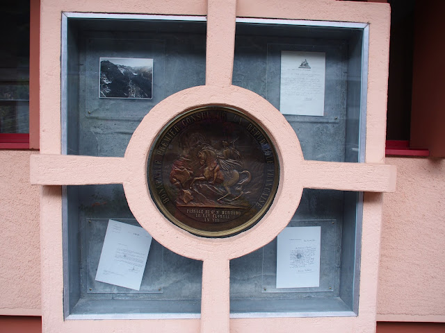
Bourg-Saint-Pierre has quite a fascinating history. It originally had a small monastery and hospice dating from the 8th and 9th centuries. These would've predated the Grand Saint Bernard Hospice by over two hundred years. In the late 18th century when armies were crossing over the pass, Bourg-Saint-Pierre was used as the final stopping point before the pass. In May 1800, Napoleon brought 40,000 troops over the Grand Saint Bernard Pass, and they stopped for the night in Bourg-Saint-Pierre. During that night the soldiers consumed 21,724 bottles of wine, 3,498 pounds of cheese, 749 pounds of salt, 400 pounds of rice, 500 pounds of bread and 1,758 pounds of meat. The bill for this stay was 40,000 Francs, and Napoleon promised them reimbursement with an IOU letter. After he was defeated, the town wasn't repaid until the French president visited the town in 1984. The town reminded him of the outstanding debt, and in response, the president sent a commemorative plaque and a handwritten letter thanking the town for their hospitality shown. He also sent 18,500 francs and the construction of a town swimming pool as restitution to which the town accepted!
When we were walking around the town exploring, we found all the letters and the plaque hung outside of the town hall!!
 |
| Commemorative plaque |
 |
| IOU letter from Napoleon |
 |
| French president's letter of restitution to Bourg-Saint-Pierre |
The town hosted several old medieval houses (or barns) that sat on high rock bases attached with small wooden beams and separated from the building by slate disks! It was the oddest combination, but we thought they might be storehouses that needed to be lifted above the snow, and the disks were a form of pest control.
 |
| We think these are to prevent rats from getting in |
In front of the church, we saw a Roman mile marker! These would've been positioned throughout the Roman roads during Roman times with many of them still standing during Medieval times, but this was the first I'd seen!
 |
| Roman mile marker |
There were several of these tiny little wooden cabins interspersed throughout the town. I found a magical tiny house that was clearly abandoned, and I have vowed to return someday to buy and renovate it! For dinner, we tried Raclette for the first time which I found that I definitely preferred to cheese fondue.
 |
| My future little Swiss chalet! |
The next day was our final ascent into the Grand Saint Bernard Pass! We passed by a medieval mill on our way out of Bourg-Saint-Pierre and stopped a while to explore it.
The water was brought down by a man made log slide that ran for at least 30 meters!
After leaving the mill, we continued through in the forest before breaking down into a ravine and climbing up the other side towards a huge dam.
 |
| More berries! |
 |
| Abandoned farm |
 |
| From here on out we noticed much of the highway road was covered with avalanche tunnels |
After an hour or so we passed by the vast dam that fed all the rivers we had crossed on the way up.
 |
| Beautiful clear blue water! |
 |
| Still following the yellow diamonds |
We stopped at the far end and enjoyed a quick break dipping our feet in the glacial water.
 |
| Brrrr! |
 |
| "What's wrong with you?" |
 |
| "I hate relaxing and taking breaks" |
While we were breaking a tour group passed by with two short haired Saint Bernard dogs. The Saint Bernards took the opportunity to play in the water as all the humans indulgently watched and took pictures of them enjoying themselves!
After our break, we pressed on! We passed by another abandoned farmstead this one open wide for all to see. I could make out a ruined bed under the debris in the main room. I wondered how long it's been abandoned and why.
 |
| Abandoned farmstead |
At the end of the lake, we saw several roads out of the valley. We played a guessing game of which one would have been the Roman road that Sigeric would've taken... Which one do you think?
 |
| There are four roads not including the one we were on! |
Once we started up from the dam, we saw the entrance into the tunnel through the mountains. On October 15 the road over the pass closes and all cars have to go through the tunnel. There was a small ski area next to the tunnel, and we saw lots of motorcycles and people with old cars driving together up to the pass. That was definitely a popular thing to do in the Summer.
 |
| Tunnel |
We continued up the side of the gorge. By this point, we had made it above the tree line, and for the next few days, we didn't see any more trees.
We ate lunch on the hillside and noticed that there were a lot of walkers on the path. It seems that this area is trendy for hikers, either day hiking or backpacking for a few days. One Swiss couple with three of the most beautiful dogs stopped and chatted with us for a bit.
We passed by a large abandoned farm from 1701 and another smaller dam. This area was gorgeous, and there were streams and wildflowers and cows with bells galore!
 |
| Pictures cannot show how insanely steep this section was! |
 |
| Break! |
From this point on the trail would follow pretty close to the main road. Usually, the pass carries snow year round. I read stories of how pilgrims had to walk in the deep snow in August up the pass! This year there was no snow below peak level. This was a combination of a low snow winter the year before and the fact that Switzerland had been having a hot summer as well. I was a little bummed not to see any snow though.
 |
| Keep following the yellow diamonds |
There were several gorgeous small waterfalls close to the path.
 |
| Sketchy bridge of doom |
 |
| "What?" |
At one point near to the top of the pass, we found a tiny building that was a safe house. It was amazing! There was a stove and emergency rations, as well as a table with benches and blankets and pillows. They also had an emergency radio and woodpile. One entire wall was full of signatures of people who had passed by over the years!
 |
| Just around the corner! |
The last two kilometers of the walk were insanely steep but we arrived finally!!!!
 |
| We can finally see the hospice! |
 |
| Well thats as high as I can reach... |
 |
| My job is done! |
 |
| Last stretch! |
 |
| VICTORYYYYYY |
 |
| 2473 meters of badass walking up! |
There was no snow around the top of the pass either which is quite rare for this time of the year. The temperature was pretty warm while we were there as well, between 50-60 Fahrenheit.
For the next two days, we were staying in the hotel that is attached to the hospice on the Swiss side of the pass. Though when I came back over the pass, I made sure to stay in the hospice as it feels like a pilgrim right of passage. The hotel, though, had been recently renovated and was very nice.
The pass is right on the border between Italy and Switzerland with one half of the lake being Swiss and the other side being Italian.
 |
| Looking towards the Italian side of the lake |
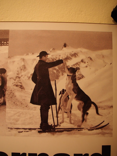
Our first stop was the Saint Bernard kennels! There were about twenty dogs in the kennels but unfortunately no puppies. Our room in the hotel overlooked the kennels, and early each morning we were woken by the happy and hungry dogs being fed and walked.
Saint Bernards were brought to the pass in the late 17th century and were originally used as way-finder dogs. Throughout the years their role slowly changed into rescue dogs for victims of avalanches. Recently they have solely become a symbol for the pass, and German Shepherds have replaced their avalanche duties as they are lighter (for use in helicopters) and easier to train.


The most famous Saint Bernard was named Barry. He was born around the beginning of the 19th century when Napoleon was crossing the Alps. There was a quote from an article in 1816 that says, "During twelve years Barry has worked and was faithful to his services towards the unfortunate. He alone saved more than forty persons. His zeal in this work was extraordinary. At no time it was necessary to urge him to work. As soon as he had the warning of somebody in danger, he would run to his aid. If, by himself, he could not save the person he would return to the convent and claim help by barking and his general attitude." Barry was so famous that he was known throughout the world and ever since his death (after he retired and died in 1814 in Bern) every generation the best dog is named after Barry.
 |
| The monks training the Saint Bernards |
Attached to the kennels is a museum on the history of the hospice, dogs, and pass. The first few rooms showed pictures and paintings of Saint Bernards working and playing and occasionally saving an avalanche victim.
 |
| The dogs and monks saving a victim |
Originally this area was inhabited by the Celts until the Roman conquest of the area by Julius Caesar in 57 BC. Then, under the rule of Augustus, a Roman road was built over the pass lined with milestones from Aosta Italy to Martigny Switzerland. One of these milestones stood by the church in Bourg-Saint-Pierre!
After the Roman's built the pass road, they built a temple to Jupiter and people would offer tablets or weapons to the temple for safe passage over the pass.
 |
| Roman ex-voto (offering tablet) |
The temple was located on the Italian side of the pass and was discovered during an archeological dig in the 18th and 19th centuries.
 |
| Temple of Jupiter with two other buildings |
After the fall of the Roman empire, the pass was abandoned and fell into ruin. For around five hundred years travelers had to brave the pass with no assurance of safety at the top or even on the roads leading up and over. Between St. Rhémy in Italy and Bourg-Saint-Pierre in Switzerland, a distance of 25 kilometers, there was no shelter. The pass was crawling with robbers and bandits who attacked and beset the unwary travelers. This, combined with the capricious weather conditions, made traveling over the pass in the early medieval ages a terrifying undertaking.
Finally, an Italian man named Bernard of Menthon, who had spent years helping travelers that had been attacked and stripped of their possessions, was granted permission by the pope to establish a hospice at the top of the pass and in 1050 he constructed the hospice. Shortly after his death, Bernard was beatified, and the pass adopted the name Grand Saint Bernard Pass. The name of the dogs came from this man as well!
Throughout the centuries the hospice has received many donations and gifts from wealthy people, allowing it to progressively grow to fill the demands of a flourishing travel route. From the beginning, the hospice has provided free food and shelter to travelers and pilgrims from the services of its Augustinian monks.
 |
| The growth of the hospice |
In the late 19th century the demands on the hospice outgrew all of its enlargements and work on a building opposite the hospice for overflow travelers began. Today the second building has become a hotel for travelers while the hospice retains its original propose of sheltering and feeding pilgrims for donations.
Until the beginning of the 20th century, the pass could only be crossed by foot or horseback. Though skis became a standard mode of travel for the monks in the winter months. In 1896 work on the road began and by 1905 it opened and continues to be used for vehicles during the summer months.
The museum then went over life at the top of the pass. During the winter months the pion-or cord- was used to help people find their way during blizzards.
My favorite thing was the embalmed body of Barry III! Barry III saved many people before he died on duty. He was leading a monk to a traveler when he slipped on ice and fell into a ravine. I thought his face looked perpetually startled and consternated... and he seems quite small compared to the Saint Bernards of today.
The marroniers were the official guides for travelers over the pass. The used Saint Bernard dogs also to help guide the way. The guild of the marroniers was usually composed of men from the nearest villages- and though this occupation was very dangerous, it also brought great income for locals.
 |
| Marroniers |
Next, there was a section on the victims of the pass. Thousands of people perished on the route from Bourg-Saint-Pierre to Aosta. In 1476 a morgue was built near the hospice for the storage of people who died on the pass. Around 200 corpses that have been mummified by the cold rest inside the morgue. Thought the morgue was closed in 1950 the building is still viewable near the hospice.

The terror of medieval pilgrims can be seen in this account from a man crossing the Alps in January 1129, "It was high morning and the pilgrims full of fear and trembling were preparing themselves to face menacing death by holy prayers. They were contending with each other to be the first to be confessed by the only priest, and as he was fully occupied they were confessing to each other their sins. As they were busy accomplishing this duty in the church a terrible news has arrived: ten of the guides who had left the village earlier have been swallowed by an enormous mass of snow and have been carried away to the abysses..."
Throughout the centuries, the Grand Saint Bernard Pass has been traversed by hundreds of famous wayfarers. The most famous probably being Napoleon with his 40,000 man army in 1800. Bourg-Saint-Pierre was not the only municipality be cleaned out by the troops!
 |
| Napoleon's army |
A more recent crossing was done by Richard Halliburton, a famous writer and world traveler, in the 1930's. Trying to reenact Hannibal's famous journey, Halliburton rode an elephant over the pass. Unfortunately, the poor animal suffered from altitude sickness and stopped on the summit.
 |
| Halliburton on his elephant |
 |
| A traveler's room in the hospice |
That night we had dinner in the hotel restaurant which was super busy with tour groups. We could tell the difference between pilgrims and tourists right off the bat! The tourists were all really old and nicely dressed while the people who had walked up the pass looked dirty and hungry!
Afterward, we walked around the hospice area and found the morgue. This was built to house the bodies of people who didn't make it and still has 200 bodies in it.
 |
| The Combe de Morte or Charnel house |
 |
| In memory of those who suffered and died on these mountains |
 |
| The gorgeous Grand Saint Bernard Pass at sunset |
The next day we were staying at the pass to rest and explore. We decided to do a hike to the top of a summit nearby and took off right after breakfast.
 |
| This used to be a chair lift for tourists to ride up to the summit |
The area around was absolutely gorgeous. There were so many bright Alpine flowers and the views were spectacular.
 |
| The Grand Saint Bernard Hospice and hotel |
The hike was rigorous up to the top of the mountain though we all agreed it felt much easier without the added weight of the packs we'd been carrying the last few days!!
 |
| A little bit of snow on the glaciers |
 |
| A great view of the lake on the pass |
 |
| This is the summit we climbed to |
 |
| Mountains all around us |
I found these signs consternating and amusing... mostly worrisome at the beginning of the steepest part of the climb.
 |
| Up we go! |
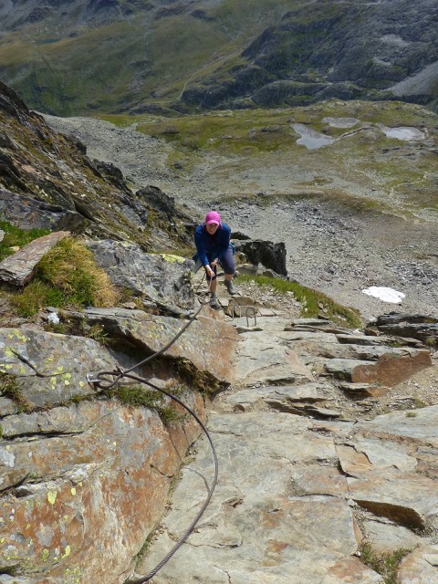
The last 300 meters of the hike was on all fours climbing using ladder, chains, and ropes to help us along!! This section was super steep and dangerous, but the views at the top were well worth it!
... and the pictures we got! :D
 |
| Everyone still here? |
 |
| Good, keep going! |
But at the top, we crested the 2900 meter mountain full of pride and adrenaline at defying death on the hike up!!
 |
| 2900 meters! |
 |
| Mountains for miles! Looking at Alps in Italy and France here! |
 |
| French Alps |
 |
| Getting my bearings |
At this time I would like to thank my long-suffering and patient parents because, though you might not realize it from the blog, they had to take upwards of a hundred photos of me at the top of this mountain because I wanted both the flags "to be perfect"... a demanding feat on a craggy windy mountaintop!! Thanks, guys *sheepish grin*
 |
| Oh man I've come so far! |
And then one of the whole team!
 |
| So happy! |
I would also like to congratulate my mom for being a badass on this hike. For someone who is scared of heights, she kicked ass!
 |
| On the way back down... if you look reaaaaallllyyyy closely you can see dad coaxing mom back down the mountain... |
After the hike, we visited the Italian side of the pass and ate at a restaurant over there. It was amazing the difference between the two sides of the pass. As soon as you crossed the border people were speaking Italian and using Euros again. We also indulged in our first real Italian cappuccino!
 |
| Walking to Italy for lunch |
 |
| Statue of St Bernard |
 |
| The area where the Roman temple of Jupiter was located |
That afternoon we visited the hospice treasury and chapel. I also received my official stamp!
 |
| The Swiss portion of my passport |
 |
| The pilgrim registry and notebook |
 |
| Beautiful drawing |
 |
| Date over the hospice kitchen |
That night it started raining and which worried us for the walk down the pass the next morning. We were planning on walking the whole 30 kilometers to Aosta which would be difficult even in good weather!
 |
| Breakfast at the hotel- all the jams were made by different monasteries! |
The next morning the rain mostly held, we only had bits of sprinkling here and there. We started the walk along the remains of the Roman road on the Italian side of the pass before crossing the main road and continuing zigzag down the slope.
 |
| Leaving the pass |
 |
| The Roman road |
 |
| Crossing over electric fences!! |
About halfway down the first slope, we passed a small hamlet, called Fonteinte, that used to have a hospice for pilgrims. It was founded in 1258 and was in use until 1791.
The weather ended up being perfect, not too cold or hot and windy enough to cool us down. It was incredibly steep in parts, and my toes were hurting during each break.
The tiny towns walking into the Aosta Valley were adorable. The village of Saint Rhémy most of all because it sported little pilgrims at the top of its street lights!! This village built up around the pilgrim route and much of its business in Medieval times centered around aiding those pilgrims. Marroniers would've also come from this town, it being so close to the pass.
 |
| Beautiful little Saint Rhémy |
 |
| Walking down the main street |
 |
| Via Francigena pilgrim on their light posts! |
As we left the first mountain slope coming down from the pass, we continued walking along the sides of the gorges, following them down into bigger and broader valleys. This side of the Alps maintained the "cute little Swiss chalet" look, and you could see little villages nestled further up different mountain gorges on the way. Though we did notice almost immediately after crossing the border that the tidiness around us was gone and the road litter reappeared :(
 |
| Collecting sap for syrup! |
 |
| This trail was super slippery on the wet grasses! |
 |
| Little mountain towns |
 |
| They used the thick rock slate for their roofs |
 |
| Cute little chalet with flowers |
 |
| Sculpture named "Pilgrims"... or was it "Dementors"?? |
Around midday, we stopped in the mid-sized town of Etroubles. This town had a large and grand looking pilgrim refuge where I was able to get my stamp!
 |
| Etroubles |
 |
| Pilgrim house |
We also got some pizza for lunch! I was ravenous, and so ordered this delicious-looking pizza! Sausage, french fries, and an egg! And the chef made it into a little heart for me!!
Leaving Etroubles, we had descended into the wider valleys where we walked along a canal for about 10 kilometers. It was very pleasant, and the views were still spectacular. There were lots of Via Francigena postings and boards with history, at least one in each town along the way, and it was immediately clear that the Italian portion of the Via Francigena would be the best waymarked and most well-known portion.
 |
| Getting tired |
 |
| Here the signs are red and white |
 |
| We can finally see Aosta! |
We reached Aosta around six, and we were all hurting from the long way down. The worst part was our toes! Some of the slopes we walked down were super steep. Also, our knees and hips were tender from the pounding and also our quads from holding the weight of both our packs and our bodies back while we walked downhill. It was a very good thing that this was our last day of walking and I would be taking a few days off before I began again.

Aosta was amazing, but we didn't get to explore it very much since it was getting late. When I came back through this section, I explored the city and will talk about it then.
The next day, weary and happy to not be carrying our packs, we drove along the length of the Aosta valley, out through the mountains and into the flatlands to Milan. We walked around Milan that day, but I was pretty nonplussed about the city. It was too modern and fashionista for my liking I think.
The following day I said goodbye to my parents and took a train back up through the Alps to return to Bar-sur-Aube and finish the French section of my trip. It was so incredible walking this portion with them, and I'm so happy they came, but I also found that I was glad to get back to the "down and dirty" living I'd been doing when I was walking alone. For whatever reason, it felt more "pilgrimy" and against all the odds I missed that!
Anyways, I will see you all next time back in France!











Comments
Post a Comment